This survey was carried out across a raised landfill site
in Southeast England, just north of the Thames. Domestic waste
had been used to fill an old quarry, the area being well-sorted
sands of the Reading Beds.
Resistance measurements were taken using some forty electrodes
at a spacing of 5 meters. The site had been clay capped and
therefore afforded good coupling.
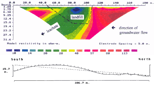
Due to elevation changed across the site the results were
corrected to a datum therefore the inverted image should be
viewed as section measured from this line.
The electrical image shows a low resistivity zone in the
centre, which corresponds to the landfill, it also suggests
that it had a sharp northern boundary but not a clear southern
one. The form of the landfill was known from boreholes and
its profile has been marked on the section. It is clear that
the area of low resistivity extends below the landfill and
in a southerly direction and represents a plume of contamination
extending from the base of the site. This is consistent with
the direction of ground water flow through the sands.